


le Rosier la Bourgarie

ARPF
User
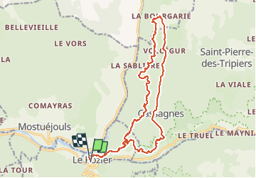

Length
24 km

Max alt
899 m

Uphill gradient
1176 m
Km-Effort
40 km

Min alt
396 m

Downhill gradient
1165 m
Boucle
No
Creation date :
2016-05-12 00:00:00.0
Updated on :
2016-05-12 00:00:00.0
8h35
Difficulty : Difficult

FREE GPS app for hiking
 SityTrail
IGN / Geographical institutes
SityTrail Plus
The world is yours!
About
Trail Walking of 24 km to be discovered at Occitania, Lozère, Le Rozier. This trail is proposed by ARPF.
Description
Les corniches du Tarn et de la Jonte au départ du Rosier
Positioning
Country:
France
Region :
Occitania
Department/Province :
Lozère
Municipality :
Le Rozier
Location:
Unknown
Start:(Dec)
Start:(UTM)
516594 ; 4893052 (31T) N.
Comments